Rock Run Trails
Back to: Map | Trail Directory
Ski Touring
21km of trails
Located north of Unionville, on Rt. 504, about 4 miles from Black Moshannon State Park. Skiing the Rock Run Trail is a more advanced and day long undertaking. However, the Entrance Trails, about a half mile in, provide several obvious easier loops to ski (unmarked). More Info
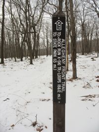
The Rock Run Trails offer a beautiful ski touring challenge. Abundant snow at high elevation and a variety of terrain make this an enjoyable adventure. An easy drive from State College, PA, the parking area for the trails is located about 4 miles east of Black Moshannon State Park off SR 504 in the Moshannon State Forest near a cluster of communication towers. Access to the Rock Run Trail is via the Allegheny Front Trail (AFT) on the north side of SR 504.
Skiing the Rock Run Trails is an all-day challenge for most. Some skiers prefer to ski the entrance area rather than travel all the way in to the Rock Run Trails system. The entrance ski trails are not marked (other than the AFT Entrance Trail leading into Rock Run) but the places to ski are obvious: an open meadow near SR 504, a lower meadow about a quarter mile in at the foot of the hill where the radio towers are perched, and the telemark and traverse hill to the west. Skiers can avoid getting lost by keeping the radio towers in view. After traveling a half mile into the main woods, you will lose sight of the towers. The map below shows some possible ski loops for the entrance area. The AFT cuts through the middle and is well used by hikers, skiers, hunters, and snowshoers.
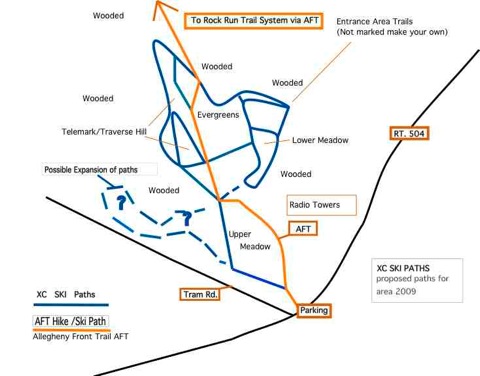
The Rock Run Trail loops, forming a rough figure 8, are about two miles from SR 504. The skiing is mostly downhill or flat to the trail register located at the point where Headwaters Trail and Woodland Trail meet. Most skiers choose to travel clockwise, northwest, from the trail register by taking Headwaters Trail, which is also the AFT. Headwaters Trail crosses a couple of streams and heads more or less downhill to the clearing near the crossover to Woodland Trail and the junction with Ridge Trail. The crossover (footbridge and short connecting path) to Woodland would provide a way to ski the upper loop of the figure 8 and would limit the mileage from SR 504 and return to 8 miles. Skiing the lower loop of the figure 8, Ridge Trail and Valley Trail adds 5 miles to the trip (13 miles total).
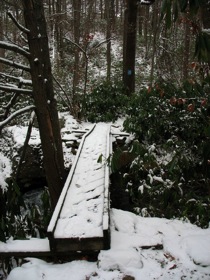
(Trail register at Headwaters and Woodland Trails. Bridge at the crossover.)
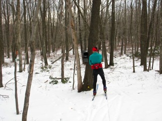
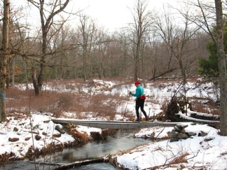
From Headwaters Trail take Ridge Trail (also the AFT at this point) and head up to the top of the ridge. The climb is moderate and once on top the path is wider and flatter through open woods. About half way on Ridge Trail the AFT cuts off to the west. Continue on Ridge Trail and be treated to a long gradual downhill. Be cautious as the downhill path could get very fast in certain conditions. Also there, can be downed trees across the trail. Pay close attention to the trail blazes as there are some sharp twists in the trail. Eventually, after this downhill journey you will arrive at Valley Trail. There is a narrow bridge crossing the Middle Branch of Rock Run and removing skis to cross is good idea.
 Valley Trail is a long gradual upgrade and it eventually meets with Woodland Trail. At this point one could take the short cross-over trail to Headwaters and Ridge Trails. Valley and Woodland Trails have several small stream crossings. Use caution when navigating the crossings. Continuing up on Woodland Trail there are some interesting boulders and eventually a narrow rhododendron passage back to the trail register. To complete the journey head south 2 miles on Entrance Trail back to SR 504. It is uphill for the most part.
The more snow cover there is, the better this trip will go. A foot or more is recommended but skiers have traveled here on less. Headwaters Trail and Ridge Trail are on the west side of the figure 8 and Woodland and Valley Trail are on the east side. The trails were well marked and had great signs as of December of 2013. There are several small stream crossings and some small bridge crossings. Be prepared for this trip by having the proper equipment, safety gear, conditioning, ski technique, and accurate maps. Allow plenty of time to complete this journey, going in is easier than coming out. If in doubt about your ability to manage this trek or if the amount of time to spare is limited, enjoy the entrance area trails and remain within a half-mile of the parking area. This is a great place to visit and lodging can be found at Black Moshannon State Park and in State College, PA.